
About Cuddalore District
Cuddalore District is one of the important coastal districts of Tamil Nadu. Located along the Bay of Bengal, the district is known for its rich history, cultural heritage, scenic beaches, ancient temples, and agricultural prosperity. Cuddalore serves as a major administrative, educational, and commercial center in the region.The district is famous for its beautiful coastline, particularly Silver Beach, one of the longest beaches in Tamil Nadu. Cuddalore also has historical importance due to landmarks such as Fort St. David, which played a significant role during the colonial period.Agriculture remains the backbone of the district’s economy, with paddy, sugarcane, groundnut, and cashew being the major crops. In addition, industries, fisheries, trade, and tourism contribute significantly to the district’s development.
Major Municipalities (The Main Cities/Towns)
These are the core urban and commercial centers of the district:
Cuddalore: The large coastal headquarters of the district, famous for Silver Beach and its ports.
Chidambaram: A deeply historic city famed globally for the ancient Thillai Nataraja Temple and Annamalai University.
Panruti: Widely celebrated as the “Jackfruit City” and a massive hub for cashew nut processing.
Virudhachalam: A major railway junction town known for its ancient temples and ceramic industries.
Nellikuppam: A town highly driven by agriculture and home to large-scale sugar manufacturing units.
Cuddalore district in Tamil Nadu is split into administrative areas called Taluks, which contain its main cities and major towns
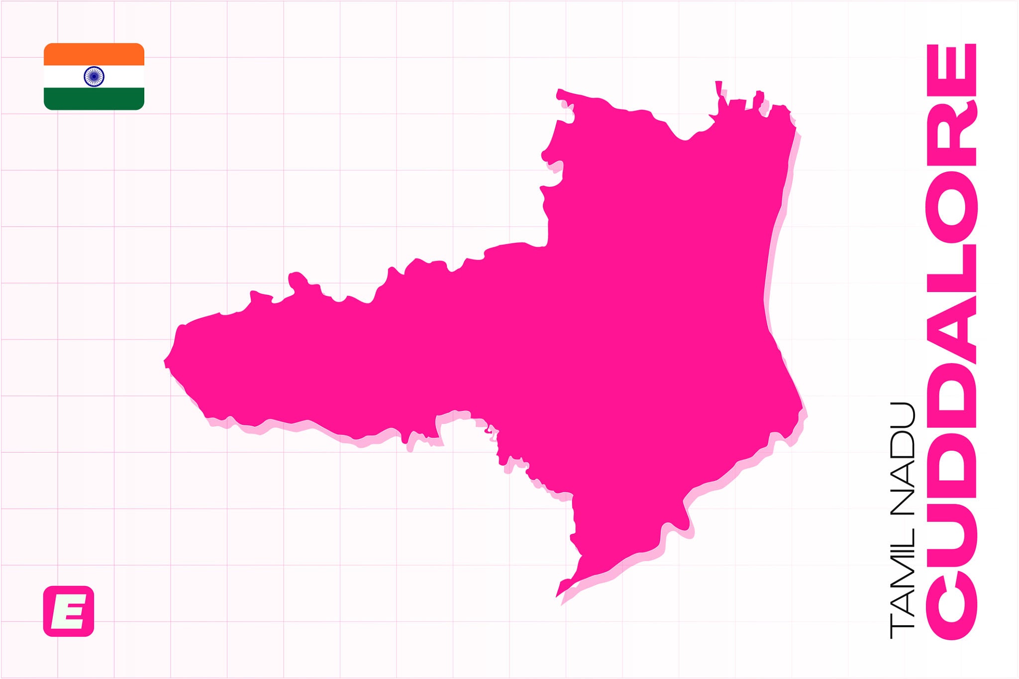
Complete Taluk List (Administrative Urban Areas)
| Taluk Name | Key Localities & Highlights |
| Cuddalore | District HQ, Thiruvanthipuram, Nellikuppam |
| Chidambaram | Annamalai Nagar, Pichavaram (famous mangrove forest), Killai |
| Panruti | Melpattampakkam, extensive cashew farming zones |
| Vriddhachalam | Central commercial hub, local ceramic manufacturing centers |
| Neyveli | Formed around the vast NLC (Neyveli Lignite Corporation) mining and power complex |
| Kattumannarkoil | Lalpet, major historic irrigation systems (Veeranam Lake area) |
| Tittakudi | Pennadam, western border agricultural hub |
| Kurinjipadi | Vadalur (famed for the Vallalar shrine), textile weaver clusters |
| Srimushnam | Famous for the historic Bhuvaraha Swamy temple complex |
| Bhuvanagiri | Birthplace of Saint Raghavendra, key agricultural marketplace |
Population of Cuddalore District
Since the official 2021 Census of India was delayed, the most definitive data comes from the 2011 Census, alongside current projected estimates for 2026.
2011 Census Population: 2,605,914
2026 Estimated Population: Approximately 2.8 to 2.9 million (based on standard regional growth rates).
Cuddalore City/Urban Area: The city itself has a population estimated around 258,000 to 308,000 depending on the extended municipal corporation limits.
Key Demographics (2011 Census Data)
Gender Ratio: 987 females for every 1,000 males (well above the national average).
Literacy Rate: 79.04% average (85.93% for males and 72.10% for females).
Urban vs. Rural: Roughly 34% of the population lives in urban areas, while 66% resides in rural parts of the district.
Major Languages: Tamil is spoken by more than 97% of the population.
Cuddalore District Demographics
Quick Summary of the Shifts:
Rural Core: Despite urban growth, roughly two-thirds of the district’s residents continue to live in rural areas, deeply tied to the regional agricultural economy.
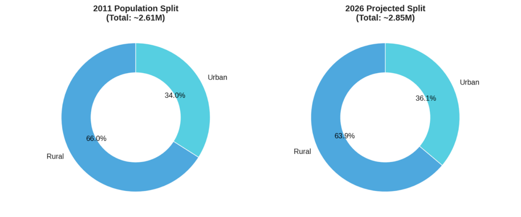
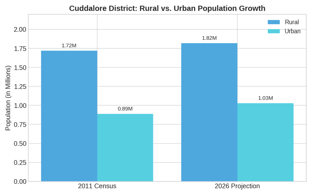
statistics for the Cuddalore District
Population & Demographics
Total Population (2011 Census): 2,605,914
Projected Population (2026): ~3,177,886 (District overall); Cuddalore Municipality/City proper is estimated at ~258,000.
Population Density: 704 to 707 persons per sq. km.
Sex Ratio: 987 females per 1,000 males (per 2011 census).
Urban vs. Rural Split: Roughly 34% live in urban areas while 66% reside in rural communities.
Religious Demographics: Hinduism (91.78%), Islam (6.09%), and Christianity (3.98%).
Principal Language: Tamil is spoken by 97.59% of the population.
2. Literacy & Education
Overall District Literacy (2011 Census): 78.04% (Male: 85.93%, Female: 70.14%).
Recent Literacy Estimate (PLFS Survey): Has grown to approximately 83.82%.
Cuddalore City Literacy: Significantly higher than the rural average at 87.71%.
3. Economy & District GDP
Gross Domestic Product (Gross District GDP): For the period, the GDDP was recorded at ₹60,79,468 lakh (~₹60,794 Crore) at current market prices.
Primary Economic Driver: Agriculture remains the backbone of the district. Major crops include paddy (rice), sugarcane, groundnut, cashews, and jackfruit.
Industrial Presence: Strongly driven by sectors like the Neyveli Lignite Corporation (NLCIL), major chemical industries in the SIPCOT industrial complex, and prominent pharmaceutical/pharma units.
Coastal Economy: Boasts a 57.5 km to 68 km coastline, making fishing a massive parallel revenue and livelihood source.
4. Geography & Climate
Total Land Area: 3,678 to 3,703 sq. km.
Forest Cover: Approximately 10.41% of the total geographical area.
Average Annual Rainfall: Varies between 1050 mm and 1400 mm, receiving heavy rainfall from the Northeast Monsoon.
Major Water Bodies: Vellar River Basin, Pennaiyar Basin, Veeranam Tank, and Wellington Reservoir.
5. Administrative Setup
Corporations: 1 (Cuddalore Municipal Corporation)
Municipalities: 5
Panchayat Unions / Blocks: 13 to 14
Village Panchayats: 683
Key Measurements of Cuddalore District
Cuddalore is a prominent coastal district located on the Coromandel Coast of Tamil Nadu.
Total Geographical Area: Approximately 3,564 to 3,703 sq. km (depending on administrative variations in coastal boundaries).
Coastline Length: Roughly 57 km along the Bay of Bengal, making it highly vulnerable to monsoons and cyclones but rich in marine resources.
Administrative Divisions:
Divided into 8 Taluks: Cuddalore, Panruti, Chidambaram, Vriddachalam, Kattumannarkoil, Titakudi, Kurinjipadi, and Veppur.
Key Transit Junctions in the District
If you are planning a route layout or mapping logistics, these four central hubs control the traffic flow:
Cuddalore Port & Town: Connects directly with Puducherry to the north and Viluppuram to the west.
Panruti: The crossroad junction heading toward western districts like Salem.
Vriddachalam: A vital rail and road junction connecting the central dry land blocks to the national highway.
Chidambaram: The southern gateway connecting to the fertile Cauvery Delta region.
.
The history of Cuddalore District in Tamil Nadu
The Name and Etymology
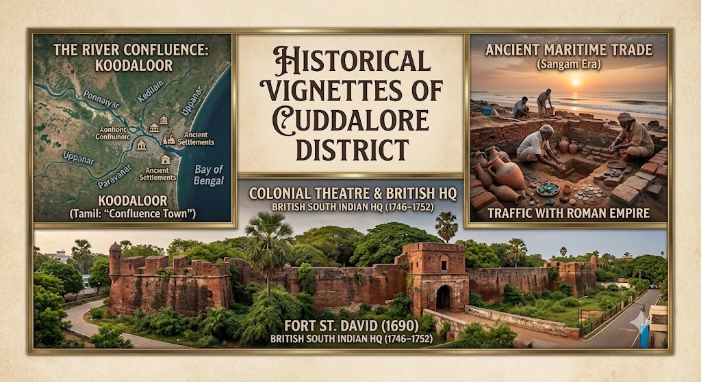
The historical roots of Cuddalore are deeply embedded in its geography and local language. Before British intervention, the region was widely known as Koodaloor (கூடலூர்), which literally translates to “Confluence Town” or “Junction Town.” This title was a direct reflection of its unique landscape, as it marked the meeting point where major rivers—including the Ponnaiyar (South Pennar), Kedilam, Uppanar, and Paravanar—converged and flowed into the sea. During periods of administration under the Nawabs, parts of the area were briefly referred to as Islamabad. Eventually, the British East India Company anglicized the traditional Tamil name Koodaloor into the modern name Cuddalore. Historically, it also formed the heart of the South Arcot District, a name derived from the Tamil term “Aaru Kadu”, meaning six forests, which local puranas hold as the ancient home of six revered rishis (saints).
Ancient and Medieval History
Long before it became a focal point for European powers, Cuddalore was a bustling maritime hub deeply integrated into global trade. Archaeological excavations at nearby Karaikadu reveal that Cuddalore’s Old Town operated as an active seaport during the ancient Sangam Era, maintaining vibrant contemporary trade links alongside Arikamedu (near Puducherry). Discoveries of ancient Roman gold coins, imported amphorae, and glassworks demonstrate that the region was highly connected to Western antiquity. As centuries progressed, this strategic coastal territory was divided between Chola Nadu and Nadu Naadu (the middle country). Because of its wealth and commercial importance, the land was heavily contested and ruled by successive regional giants, including the Pallavas, Medieval Cholas, Pandyas, the Vijayanagar Empire, and the Marathas.
The Colonial Theatre
Owing to its prime coastal location and well-established port, Cuddalore became a crucial prize during the European scramble for power in India, drawing the attention of the Dutch, Portuguese, French, and British. In 1690, the British East India Company secured the area and constructed Fort St. David. The fort proved so strategically formidable that when Madras (Chennai) fell under French occupation in the mid-18th century, Fort St. David served as the headquarters of the British South Indian Presidency from 1746 to 1752. Consequently, Cuddalore became a literal battleground during the Carnatic Wars and the Seven Years’ War, with control over the fort rapidly changing hands between the British and the French (who allied with Tipu Sultan) until British dominance was permanently consolidated in 1795. This turbulent era also paved the way for national resistance; the historic Cuddalore Central Prison, established in 1865, eventually became a prominent site of India’s freedom struggle where legendary nationalist leaders and revolutionary poets like Subramania Bharati were jailed.
Modern Formation
Following India’s independence, Cuddalore continued to serve as the administrative capital of the expansive South Arcot District, carrying forward its long legacy of governance. This vast administrative setup remained intact until September 30, 1993, when the government officially bifurcated the region to ensure better governance and development. The split divided the territory into two distinct zones: Villupuram District and Cuddalore District, with the latter retaining its historic coastal capital. Today, modern Cuddalore has evolved far beyond its colonial fortresses, standing proud as a vital industrial and agricultural powerhouse for Tamil Nadu—widely celebrated for the sprawling Neyveli lignite mines, its global cashew processing networks, and its enduring regional title as the “Sugarbowl of Tamil Nadu.”
Revenue Villages Overview
Each taluk contains dozens of individual revenue villages responsible for local land records, patta transfers, and agricultural revenue monitoring:
Chidambaram Taluk: ~183 villages
Virudhachalam Taluk: ~166 villages
Kattumannarkoil Taluk: ~151 villages
Tittakudi Taluk: ~130 villages
Panruti Taluk: ~99 villages
Cuddalore Taluk: ~73-84 villages (including areas like Alapakkam, Thiruvanthipuram, and Nallathur)
Kurinjipadi Taluk: ~56 villages
Note on Development vs. Revenue: While revenue matters go through the Taluks and Firkas listed above, developmental work (like local roads and rural schemes) is handled separately through the district’s 13 Community Development Blocks (e.g., Annagramam, Kammapuram, Komaratchi).